ITI Surveyor 2nd Year CBT Exam Practice Paper 4
ITI Exam की बेहतर तैयारी के लिये सर्वेक्षक ट्रेड का ITI Surveyor 2nd Year CBT Exam Practice Paper तैयार किया गया है जिसमे आपको 50 प्रश्न दिए जायेंगे और ITI Surveyor 2nd Year CBT Exam Practice Paper New NIMI Pattern पर आधारित है। ITI Surveyor 2nd Year CBT Exam Practice Paper मे जो प्रश्न दिये गये है वह हिंदी और अंग्रेजी दोनो भाषाओ में है।
ITI Surveyor Trade के महत्वपूर्ण प्रश्नो का ITI Fitter 2nd Year CBT Exam Practice Paper देने के लिये नीचे दिये गये ITI Surveyor 2nd Year CBT Exam Practice Paper पर क्लिक करें। उसके बाद Start Quiz पर क्लिक करें।
Q1. Which form of energy moves with the velocity of light? / ऊर्जा का कौन सा रूप प्रकाश के वेग के साथ चलता है?
Q2. What is the name of device used to measure the height of high and low waters? /उच्च और निम्न जल की ऊँचाई मापने के लिए प्रयुक्त उपकरण का नाम क्या है?
Q3. What is the time that elapse between the generation of spring tide and its arrival at the place ? / वह कौन सा समय है जो स्प्रिंग टाइड के उत्पन्न और जगह पर आने के बीच है?
Q4. What is the process of caching objects that hide in the world with GPS co-ordinates? / जीपीएस को-ऑर्डिनेट्स के साथ दुनिया में छिपने वाली वस्तुओं को कैच करने की प्रक्रिया क्या है?
Q5. Which projections has concentric circles for parallels and their radii for meridians? / मेरिडियन के लिए समानताएं और उनकी त्रिज्या के लिए कौन से अनुमान केंद्रित हैं?
Q6. What is the purpose of the theory of cartographic projection? / कार्टोग्राफिक प्रक्षेपण के सिद्धांत का उद्देश्य क्या है?
Q7. Why should Digital instrument is used? / डिजिटल साधन का उपयोग क्यों किया जाना चाहिए?
Q8. What is the least horizontal distance between two consecutive contour? / दो लगातार कंटूर के बीच कम से कम हॉरज़ॉन्टल दूरी क्या है?
Q9. How site plan is prepared after finishing field work in total station survey? / टोटल स्टेशन सर्वे में फील्ड वर्क खत्म करने के बाद साइट प्लान कैसे तैयार किया जाता है?
Q10. Which type of survey is determined the additional details such as boundaries of field, houses and to this properties path way? / किस प्रकार के सर्वेक्षण में अतिरिक्त विवरण निर्धारित किए जाते हैं जैसे कि क्षेत्र, घरों की सीमाओं और इस गुण मार्ग तक?
Q11. What are the granular materials of crushed stones provided under and around the sleepers? / स्लीपर्स के नीचे और आसपास प्रदान किए गए कुचल पत्थरों के दानेदार सामग्री क्या हैं?
Q12. Which is not an application of total station? / टोटल स्टेशन का एक उपयोग नहीं है?
Q13. Who issues recommendations on marks for towers? / टावरों के लिए चिह्नों हेतु अनुशंसा कौ करता है?
Q14. What is the maximum effective spam to the overall depth of a cantilever one way slab? / कैंटिलीवर वन वे स्लैब की गहराई पर अधिकतम प्रभावी स्पैम क्या है?
Q15. The angle subtended by chord at any point on the circumference is equal to angle between… / परिधि पर किसी भी बिंदु पर कॉर्ड द्वारा घटाया गया कोण बीच के कोण के बराबर है।
Q16. Which is the main parameter used in Pseudo ranging? / सूड़ो रेंजिंग में प्रयुक्त मुख्य पैरामीटर कौन सा है?
Q17. Which estimate is prepared for the technical sanction of the competent authority? / सक्षम प्राधिकार की तकनीकी स्वीकृति के लिए कौन सा अनुमान तैयार किया गया है?
Q18. Which projections preserve directions from one or two points? / कौन से अनुमान एक या दो बिंदुओं से दिशाओं को संरक्षित करते हैं?
Q19. Which is an orderly index system suitable for a series of map of different scale? / जो अलग-अलग पैमाने के नक्शे की एक श्रृंखला के लिए एक क्रमबद्ध सूचकांक प्रणाली है
Q20. Which colour is used to represent Toponymy in topographical map? | स्थलाकृतिक मानचित्र में टॉपोनामी का वर्णन करने के लिए किस रंग का उपयोग किया जाता है?
Q21. Which structural component provides a base for the Superstructure? / कौन सा संरचनात्मक घटक अधिरचना के लिए आधार प्रदान करता है?
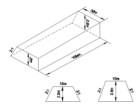
Q22. What is the quantity of earth work in the given figure by average height method? / औसत ऊँचाई विधि द्वारा दी गई आकृति में मिट्टी के काम की मात्रा कितनी है?
Q23. What is the maximum super elevation provided for metre gauge? / मीटर गेज के लिए प्रदान की जाने वाली अधिकतम सुपर ऊंचाई क्या है?
Q24. What is ʹXʹ in the figure? / आकृति में ʹXʹ क्या है?

Q25. Which direction is best to orient the total station for obtaining best output? / सर्वश्रेष्ठ आउटपुट प्राप्त करने के लिए टोटल स्टेशन को उन्मुख करने के लिए कौन सी दिशा सबसे अच्छी है?
Q26. Which are the special points of geographic co-ordination? / भौगोलिक समन्वय के विशेष बिंदु कौन से हैं?
Q27. Which are mounted on the satellites in satellite remote sensing? / सेटेलाइट सुदूर संवेदन में सेटेलाइटों पर कौन से लगे होते हैं?
Q28. Which transmission towers has pegs set along the center line of route alignment? / मार्ग संरेखण के केंद्र की रेखा के साथ खूंटे को किस ट्रांसमिशन टॉवर में स्थापित किया गया है?
Q29. Which is a data base for geographic location? / भौगोलिक स्थान के लिए डेटा बेस कौन सा है?
Q30. Which is the next step of preliminary survey? / प्रारंभिक सर्वेक्षण का अगला चरण कौन सा है?
Q31. How many nations attended in the international Meridian conference? / इंटेरियन मेरिडियन सम्मेलन में कितने देशों ने भाग लिया?
Q32. Which vertical curve convexity upward? / कौन सा ऊर्ध्वाधर वक्र उत्तलता ऊपर की ओर है?
Q33. Which program is used to create parallel line with respect to a base line? / बेस लाइन के संबंध में समानांतर रेखा बनाने के लिए किस प्रोग्राम का उपयोग किया जाता है?
Q34. Which of the feature represented by BLACK colour on Topographical map? / स्थलाकृतिक मानचित्र पर काले रंग द्वारा दर्शाए गए विशेषता में से कौन सा?
Q35. What are the initial settings required for a digital planimeter? / डिजिटल प्लानिमीटर के लिए आवश्यक प्रारंभिक सेटिंग्स क्या हैं?
Q36. Which is the reference place on the map for a description, explanation table of symbols or other information for better understanding? / बेहतर समझ के लिए विवरण, प्रतीकों की व्याख्या तालिका या अन्य जानकारी के लिए मानचित्र पर संदर्भ स्थान कौन सा है
Q37. What is the distance between point of inter section to point of tangency? / अंतर खंड के बिंदु से टेंजेंट के बीच की दूरी क्या है?
Q38. Which tide gauge gives a graphical record? / कौन सा ज्वार गेज ग्राफिकल रिकॉर्ड देता है?
Q39. Which bar has its surface roughened to increase the resistance to slipping? / फिसलने के प्रतिरोध को बढ़ाने के लिए किसकी सतह खुरदरा किया जाता है?
Q40. How a range line is marked in soundings ? / साउंडिंग में एक रेंज लाइन कैसे चिह्नित की जाती है?
Q41. What is IHO? / IHO क्या है?
Q42. Which segments can use GPS receiver? / GPS रिसीवर किस सेगमेंट का उपयोग कर सकता है?
Q43. Which degenerate in to circles? / सर्कल में क्या डिजेनरेट होता है ?
Q44. Which curve is set out by taking offsets from the tangents? / टेंजेंटरेखा से ऑफसेट लेकर किस वक्र को बाहर निकाला जाता है?
Q45. Which is called the design span? / जिसे डिज़ाइन स्पैन कहा जाता है?
Q46. Which command used for drafting smooth irregular curve and shapes that are difficult to draw as arc? / स्मूथ अनियमित वक्र और आकृतियों को प्रारूपित करने के लिए किस कमांड का उपयोग किया जाता है जो चाप के रूप में बनाना मुश्किल है?
Q47. What is the width of metre gauge in railway track? / रेलवे ट्रैक में मीटर गेज की चौड़ाई कितनी है?
Q48. Which is having the same principle as that of determining position in GPS? / जीपीएस में स्थिति का निर्धारण करने के रूप में समान सिद्धांत है?
Q49. Which is the device that accepts incoming signals and converts them to a waste form? / कौन सा उपकरण है जो आने वाले संकेतों को स्वीकार करता है और उन्हें वेस्ट रूप में परिवर्तित करता है?
Q50. Where did transition curve provide ease and gradual change of direction in? / कहाँ ट्रानजिशन वक्र ने दिशा में आसानी और क्रमिक परिवर्तन प्रदान किया।
surveyor 2nd year cbt exam paper 4
You got {{userScore}} out of {{maxScore}} correct
{{title}}
{{image}}
{{content}}