ITI Surveyor 2nd Year CBT Exam Practice Paper 3
ITI Exam की बेहतर तैयारी के लिये सर्वेक्षक ट्रेड का ITI Surveyor 2nd Year CBT Exam Practice Paper तैयार किया गया है जिसमे आपको 50 प्रश्न दिए जायेंगे और ITI Surveyor 2nd Year CBT Exam Practice Paper New NIMI Pattern पर आधारित है। ITI Surveyor 2nd Year CBT Exam Practice Paper मे जो प्रश्न दिये गये है वह हिंदी और अंग्रेजी दोनो भाषाओ में है।
ITI Surveyor Trade के महत्वपूर्ण प्रश्नो का ITI Fitter 2nd Year CBT Exam Practice Paper देने के लिये नीचे दिये गये ITI Surveyor 2nd Year CBT Exam Practice Paper पर क्लिक करें। उसके बाद Start Quiz पर क्लिक करें।
Q1. Which means the sanction of the detailed estimate by the competent authority of the engineering department? / इंजीनियरिंग विभाग के सक्षम प्राधिकारी द्वारा विस्तृत अनुमान की मंजूरी का मतलब क्या है?
Q2. Which process is used for the transmission of radio signals from the satellites in to the GPS receivers? / सेटेलाइटों से जीपीएस रिसीवरों के अनुपात संकेतों के प्रसारण के लिए किस प्रक्रिया का उपयोग किया जाता है?
Q3. What is the maximum super elevation provided for metre gauge? / मीटर गेज के लिए प्रदान की जाने वाली अधिकतम सुपर ऊंचाई क्या है?
Q4. What is the distance between A and 42 m contour given that the distance between A and B is 10m and have reduced levels 41.3 and 43.8 m, contour interval 1m? / A और 42 m कंटूर के बीच की दूरी क्या है कि A और B के बीच की दूरी 10 मी है और स्तर 41.3 और 43.8 मीटर, कंटूर अंतराल 1 मी।
Q5. Which type of survey is determined the additional details such as boundaries of field, houses and to this properties path way? / किस प्रकार के सर्वेक्षण में अतिरिक्त विवरण निर्धारित किए जाते हैं जैसे कि क्षेत्र, घरों की सीमाओं और इस गुण मार्ग तक?
Q6. Which techniques is used for producing three dimensional co-ordinates from two dimensional photography? / दो आयामी फोटोग्राफी से तीन आयामी समन्वय बनाने के लिए किस तकनीक का उपयोग किया जाता है?
Q7. What powered cordless operation of digital planimeter? / डिजिटल प्लानिमीटर का समन्वित संचालन क्या है?
Q8. Which of the feature represented by BLACK colour on Topographical map? / स्थलाकृतिक मानचित्र पर काले रंग द्वारा दर्शाए गए विशेषता में से कौन सा?
Q9. Which program is used to locate the instrument station with respect to two known points? / दो ज्ञात बिंदुओं के संबंध में इन्स्ट्रुमेंट स्टेशन का पता लगाने के लिए किस प्रोग्राम का उपयोग किया जाता है?
Q10. What is the amount of overload factor of a suspension tower? / एक सस्पेशन टॉवर के अधिभार कारक का मात्रा क्या है?
Q11. Which is code deals with the construction of R.C.C. structures? / RCC संरचनाओं के निर्माण के साथ कोड डील कौन से हैं?
Q12. Which structural component provides a base for the Superstructure? / कौन सा संरचनात्मक घटक अधिरचना के लिए आधार प्रदान करता है?
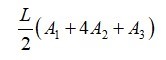
Q13. How did you find the volume of earth work between two adjacent contour using trapezoidal formula? / ट्रैपोज़ाइडल फार्मूले का उपयोग करके दो आसन्न कंटूर के बीच पृथ्वी के आयतन की मात्रा को आपने कैसे पाया?


Q14. What formula for length of long chord? / लंबे कॉर्ड की लंबाई के लिए क्या सूत्र है?


Q15. Which survey instrument supports local language? / कौन सा सर्वेक्षण उपकरण स्थानीय भाषा का सपोर्ट करता है?
Q16. What is the total length of the curve from point of commencement to point of tangency? / टेंजेंट के बिंदु से शुरू होने के बिंदु से वक्र की कुल लंबाई क्या है?
Q17. Which projection preserves the property of Azimuthality? / कौन सा प्रक्षेपण अज़ीमुथल की गुण को संरक्षित करता है?
Q18. Which is the computer program that process data linked to certain places? / कंप्यूटर प्रोग्राम कौन सा है जो डेटा को कुछ स्थानों से लिंक करता है?
Q19. When the International Meridian conference was held? / इंटरनेशन मेरिडियन सम्मेलन कब आयोजित किया गया था?
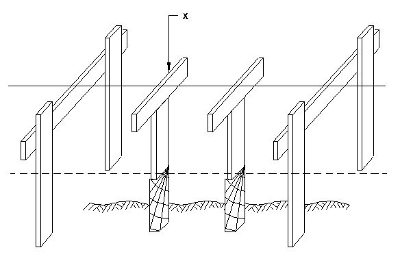
Q20. What is marked as ʹxʹ? / ʹXʹ के रूप में क्या चिह्नित है?

Q21. What is the controlling factor for locating a highway or canal on a contour map? / एक कंटूर मानचित्र पर एक राजमार्ग या नहर का पता लगाने के लिए नियंत्रण कारक क्या है?
Q22. Which projections are used often for mapping polar regions? / ध्रुवीय क्षेत्रों के मानचित्रण के लिए अक्सर कौन से प्रॉजेक्शन का उपयोग किया जाता है?
Q23. Which beam has its one or both ends project beyond the supports? / किस बीम के सहारे एक या दोनों छोर होते है?
Q24. Which is a particular case of azimuthal projection? / अज़ीमुथल प्रक्षेपण का एक विशेष स्थिति कौन सी है?
Q25. Which vertical curve having the convexity down ward? / कौन सा वर्टिकल वक्र वार्ड के नीचे उत्तलता रखता है?
Q26. Which instrument is used for preliminary survey of hill road quickly? / पहाड़ी सड़क का शीघ्रता से प्रारंभिक सर्वेक्षण करने के लिए किस यंत्र का प्रयोग किया जाता है ?
Q27. Which footing distributes the load over larger area by Widening the base? / आधार को चौड़ा करके किस फुटिंग से बड़े क्षेत्र पर भार वितरित होता है?
Q28. What is marked as ʹxʹ? / ʹXʹ के रूप में क्या चिह्नित है?
Q29. What is the angle between the equatorial plane and the straight line? / भूमध्यरेखीय समतल और सीधी रेखा के बीच का कोण क्या है?
Q30. Which method of interpolation of contour is laborious, tedious but most accurate? / कंटूर के प्रक्षेप का कौन सा तरीका श्रमसाध्य, कठिन लेकिन सबसे सटीक है?
Q31. Which works on the principle of the measurement of distance between the receiver and the satellite? / जो रिसीवर और उपग्रह के बीच की दूरी के माप के सिद्धांत पर काम करता है?
Q32. Which is the interval of masonry pillars for the centre line of alignment of railway? / रेलवे के संरेखण की केंद्र रेखा के लिए मेसनरी स्तंभों का अन्तराल कौन सा है?
Q33. What is the science of measurement and description of features which affect the marine construction navigation, etc.,? / माप का विज्ञान क्या है और सुविधाओं का वर्णन जो समुद्री निर्माण नेविगेशन आदि को प्रभावित करता है
Q34. Which is the maximum particle size of the fine aggregates? / फाइन एग्रीगेट का अधिकतम कण आकार कौन सा है?
Q35. Where were the scientific foundations of cartographic laid? / कार्टोग्राफिक की वैज्ञानिक नींव कहाँ रखी गई?
Q36. Which is the velocity of satellite in space segment? / अंतरिक्ष खंड में उपग्रह का वेग कौन सा है?
Q37. Which waste material is obtained from the thermal power stations? / थर्मल पावर स्टेशनों से कौन सा अपशिष्ट पदार्थ प्राप्त होता है?
Q38. What is the representation of ʹOʹ in the figure? / आकृति में ʹOʹ का प्रतिनिधित्व क्या है?

Q39. What is the chemical formula for limestone? / चूना पत्थर का रासायनिक सूत्र क्या है?
Q40. Which is not an application of total station? / टोटल स्टेशन का एक उपयोग नहीं है?
Q41. What is the expansion for GPS? / जीपीएस के लिए विस्तार क्या है?
Q42. What is ʹXʹ in the figure? / आकृति में ʹXʹ क्या है?

Q43. Which current meter measures the displacement of an oceanographic drifter? / कौन सा करेंट मीटर एक एसियनो ग्राफिक ड्रिफ्टर के विस्थापन को मापता है?
Q44. What is the distance of transmission line poles from fire hydrants? / फायर हाइड्रेंट से ट्रांसमिशन लाइन पोल की दूरी कितनी है
Q45. Which is works on the principle of transmitting sound waves from shipʹs bottom? / जहाज के तल से ध्वनि तरंगों को संचारित करने के सिद्धांत पर कौन सा काम करता है?
Q46. Which rocks have clay as its base component? / इसके आधार घटक के रूप में किन चट्टानों में मिट्टी होती है?
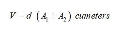
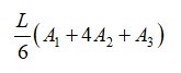
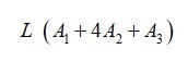
Q47. Which is prismoidal formula for volume? / वॉल्यूम के लिए प्रिज़्मोइडल फॉर्मूला कौन सा है?

Q48. What is ENH in input parameters of total station? / टोटल स्टेशन के इनपुट मापदंडों में ईएनएच क्या है?
Q49. Which map contains the boundaries of all land parcels and contains methodically arranged information about details? / कौन से मानचित्र में सभी भूमि खंड की बाउंड्री हैं और इसमें विवरण के बारे में व्यवस्थित रूप से जानकारी है?
Q50. Which is based in GPS system,that gives a user an accurate position. / GPS प्रणाली का आधार क्या है, जो उपयोगकर्ता को सटीक स्थिति बताता है?
Surveyor 2nd Year cbt exam paper 3
You got {{userScore}} out of {{maxScore}} correct
{{title}}
{{image}}
{{content}}